Lytham walk route plan
Distance 4.88 miles. Time to complete 1 hour 50 minutes. Total accent 146 feet
Our walk starts and ends at the Booth's Supermarket, Haven Road, Lytham, FY8 4ER primarily because it provides three hours of free car parking. A short walk across the road onto Cleveland Road to the next railway bridge being Station Road by the railway station. We take the path at the top of the bridge into the wonderful Witch Wood where we continue into Ansdell. A short hop through surburban streets onto Fairhaven Lake where we pass the Spitfire Memorial then back into Lytham along the sea front, finsishing back at Booths. There are two excellent pubs along the way. The Station Tavern and the The Queens Hotel. Both serve excellent food and are dog friendly. It can get a little muddy through Witch Wood so walking boots are recommended.

Related pages...
Great Eccleston walk route plan.
more Distance 2.5 miles. Time to complete 1 hour 10 mins. Accent 90 feet.
Avenham Park walk route plan.
more Distance 4.6 miles. Time to complete 2 hours 4 mins. Accent 86 feet.
The Hand and Dagger walk route plan.
more Distance 3.27 miles. Time to complete 2 hours 5 minutes. Total accent 119 feet
The Plough at Eaves route walk plan.
more Distance 3.46 miles. Time to complete 1 hour 53 minutes. Total accent 92 feet.
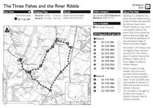
The Three Fish's Walk plan route.
more Venue: The Three Fish's, Mitton Road, Mitton, Clitheroe, Lancashire. BB7 9PQ Telephone 01254 826888