2006 Walk
THE SQUARE CORNERED ROUNDABOUT
Sunday 10 September, 2006
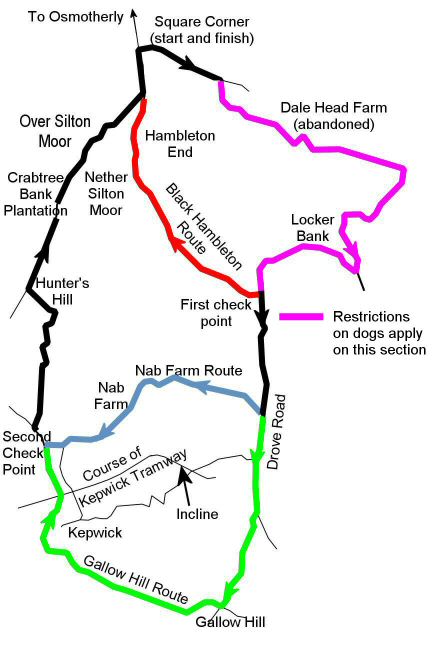
The map shows the three possible walks in the Hambledon - Kepwick area of the North York
National Park.
This year, we offered three routes starting from Square Corner, about two miles south-east of Osmotherly on the Hawnby road and overlooked by Black Hambleton. All the walks started eastwards along the road towards Hawnby for about half a mile before turning on to the track to the abandoned farm at Dale Head. We continued past the farm in the same direction until a wall was met where we turned right to ascend to the escarpment. Once at the top, the track led to the right along the top of Black Hambleton to join the Cleveland Way at the first check point. Here the Black Hambleton route (6.5 miles) turned right to return to the start along the Drove Road used in ancient times to drive cattle from the north. The other two routes turned left to go south along the Drove Road. The Nab Farm route (10.5 miles) descended into the valley past the farm of that name whilst the Gallow Hill route (12 miles) continued on the Drove Road before descending gently to Kepwick village past Gallow Hill. From Kepwick, the path crossed over the Kepwick Tramway (built in 1833) which ran from quarries up in the hills to the stoneyards and limekiln near Leake church. The two longer routes joined at the second check point to go over fields to Hunters Hill before entering Silton Forest. The walk ended with a stroll along forest tracks to emerge on the Drove Road below Hambleton End.
Dogs are strongly discouraged over the route to the first check point (coloured dark pink) because of rare birds, but if you particularly wish, they will be permitted provided the dog is kept on a short lead and does not leave the path. Alternatively you can go directly to the first check point reducing the length of each walk by 2 miles
Related pages...
The Millennium Walk
Charles Wyatt Memorial Walk
more Charles Wyatt Memorial Walk
2007 Walk
2008 Walk
2009 Walk
2010 Walk
2011 Walk
2012 Walk
2013 Walk
more A description of our last but one Sponsored Walk
2014 Walk
more Goodbye to all our friends .....
